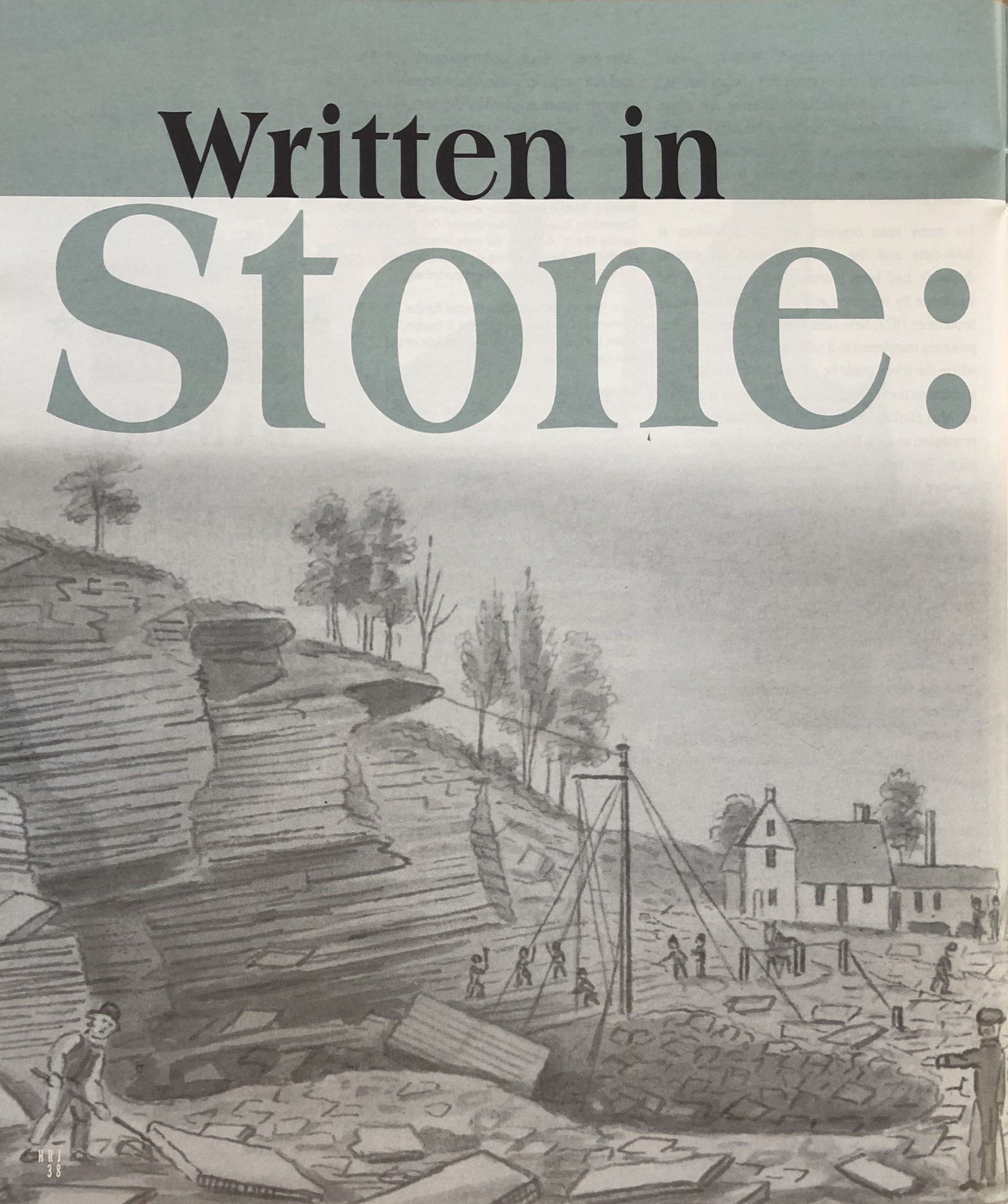
Extracting slate from the Bolton stone quarry, John Warner Barber, 1836. Connecticut Historical Society Museum, Hartford
How Connecticut’s Landscape Shapes our Lives
by Collin Harty
(c) Connecticut Explored Inc. SUMMER 2006
Subscribe/Buy the Issue!
In his book Stone by Stone, The Magnificent History in New England ‘s Stone Walls (Walker & Company, 2002), Robert Thorson notes that “The lifting strength of the human skeleton reaches a maximum midway between the knees and the hips. Once the stone has been lifted, person and stone become a single mechanical entity with a common center of gravity. A stone held at arm’s length can be swung in gentle upward arc like a simple pendulum hung from the shoulders.” And so, through basic principles of biomechanics, the size, shape, and structure of New England ‘s stone walls are a physical expression of the people that made them.
Just as stone walls are a reflection of the forces that shaped them, the lives of the people in Connecticut have been shaped by the physical and biological processes at work here. The way we feed, shelter and clothe ourselves, our social, political, and economic structures, the way we meet our spiritual and aesthetic needs and our need for recreation, and the advancement of our technologies have all been influenced by our state’s geology, climate, hydrology, and plant and animal life. Historically, our lives have subtly reflected the place in which we live.
As has often been noted, in today’s culture our technologies increasingly isolate us from nature. We hunt and gather in supermarkets. The links between the products we buy and the resources needed to produce them have become abstracted by mass production, marketing, and multi-nationalism. When we pour our waste down the drain, it disappears from our consciousness, too. But if you allow that we study the past to better understand our lives in the present, a survey of our environmental history challenges the notion that we are isolated from nature. By looking back we can see how the quality of life we live today is inextricably linked to the dynamic relationship between our natural history and our cultural history.
This article explores one facet of this relationship: the ways in which geology has shaped culture. Thorson wrote, “Stone walls lie at the intersection of science and history.. The placement of walls on the landscape coincides with nature’s placement of the stones.” Pick up almost any rock from one of Connecticut ‘s stone walls for a glimpse into the region’s geological past.
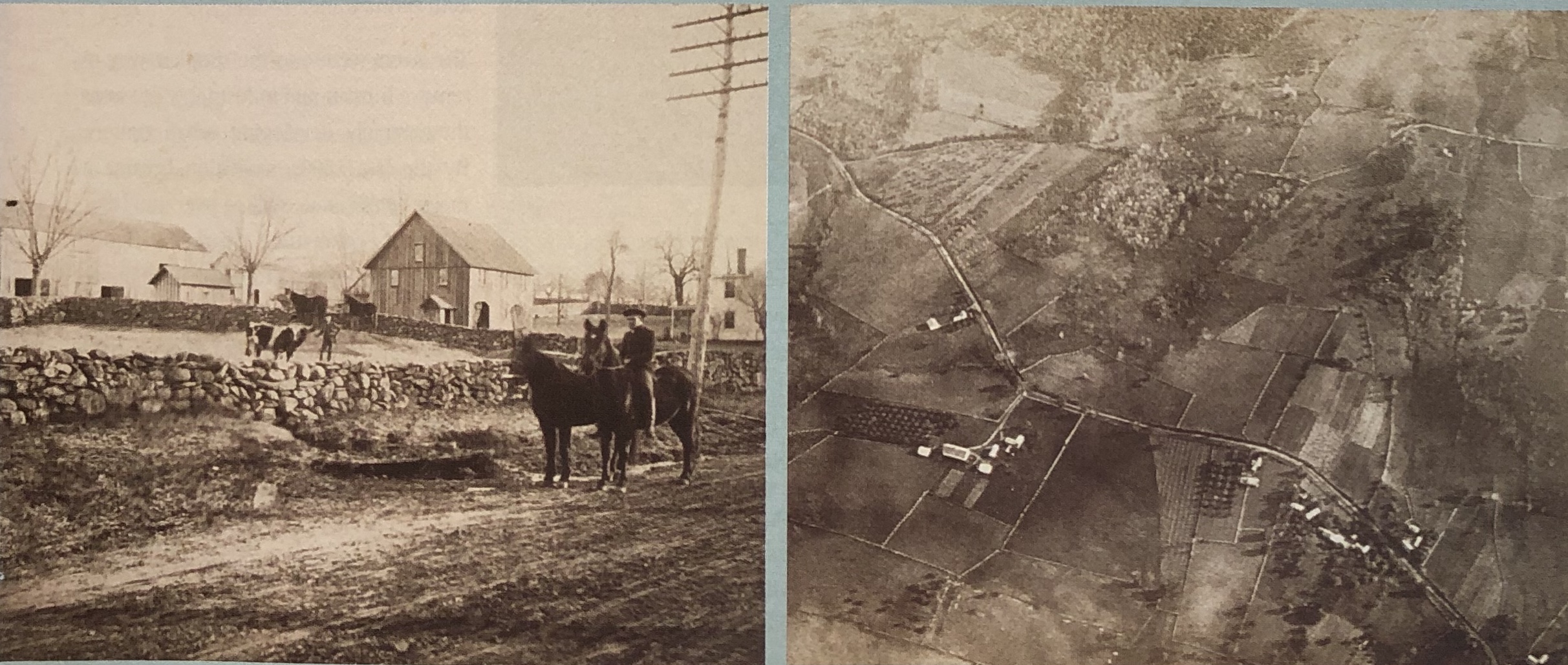
left: stone walls on the farm of G. Newman, New Milford, c. 1880s. Right: Aerial view of Bloomfield from a balloon, John G. Doughty, 1885. Farm of S. B. Pinney at center. Connecticut Historical Society Museum, Hartford
Granite, for instance, is a hard, tight, uniformly grained rock, often with distinct dark and light flecks. One of Connecticut’s oldest rocks, it formed when sediments from an ancient ocean that once overlaid this area some half a billion years ago were pushed so deep underground that pressure and heat from the earth’s core caused the material to melt and re-crystallize into a new form as it cooled.
Gneiss and schist are the most common rock types in the state. Gneiss often shows clear dark and light bands, while schist can be less distinctly banded, with a wood-like grain. Like granite, both were formed under the influences of high temperature and pressure, but here the sediments of the earlier sea were metamorphosed by a great convergence of continents 300 million years ago. The slow-motion crash of great land masses pushed skyward enormous north/south-oriented bands of mountains, whose worn stubs we now call the Appalachians . As the continents began to pull apart to form the Atlantic basin, a rift was created down the center of the state; we call that rift the Connecticut Valley . Lava erupted between the diverging tectonic plates and crystallized into a dark, fine- grained volcanic rock called basalt. In Connecticut we know it as traprock.
Over millions of years the constant effects of wind and water eroded the mountains, carrying debris down into the lowlands and out to the ocean, where it formed the continental shelf. These sediments accumulated in the Connecticut Valley for hundreds of thousands of years, until, under the force of their own weight, they fused together into the soft, reddish-brown sedimentary rock we know as brownstone.
On any one of these pieces of granite, gneiss, schist, basalt, or brownstone you might find the incised striations that are evidence of the last great geological disturbance in New England, glaciation. As the world’s climate cooled, arctic ice advanced south, until more than a mile of ice-covered parts of this region. The last ice sheet moved across the state 20,000 years ago. Beneath the glacier, the moving ice plucked stones from the bedrock and carried them on a slow march south. The weight of the ice crushed rock into mud and grounded stone against stone, producing the striations still evident today. As the climate warmed, the ice retreated, and great torrents of melt water transported rock, sand, and silt into the river valleys.
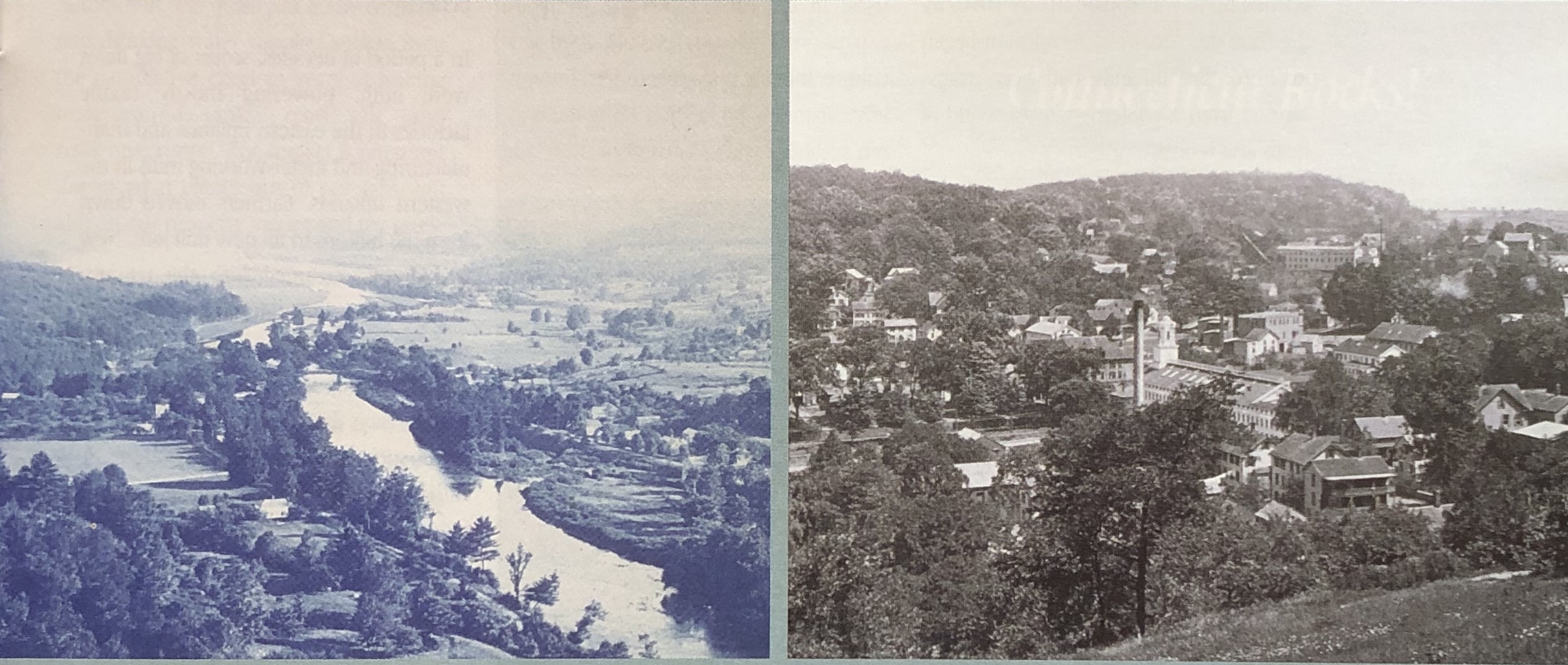
left: Farmington River, Barkhamsted, c. 1880 1899. right: The Rock Manufacturing Company (center) and Stone Mill (far right), Rockville, 1900. Connecticut Historical Society Museum, Hartford
Connecticut was again ice-free by about 15,000 years ago, but it was a bleak, windy world, littered with broken, worn pieces of rock and a tightly packed, lifeless soil. Out of this barren world rose a slow succession of plant and animal life. First there was tundra, a community of tiny flowers and shrubs tolerant of the wind and cold. On the tundra grazed vast herds of caribou. As the climate continued to warm, the tundra gave way to conifers-spruce and pine-and then birch, oak, maple, and more. Mastodons browsed the early forests. The roots of the plants broke apart the hard glacial soil, and year after year leaf litter accumulated among the glacial stones to form a rich, dark soil. Wolves, bears, deer, and birds filled out the woodland ecosystem.
Among the rocks in any stone wall you might locate a stained, cracked campfire stone that hints at the Connecticut ‘s first people. The earliest archaeological evidence of Native American activity in the state goes back 10,190 years and was produced by carbon-dating a charcoal hearth unearthed along the banks of the Shepaug River in Washington Depot. It was part of a particularly rare undisturbed archaeological site that contained a large quantity of diverse tools. From the distribution and number of artifacts it appeared fewer than 20 people used the camp and that they stayed for less than month and never returned. This pattern repeats itself in the relatively limited number of Paleo-Indian sites found in Connecticut . From it we learn that their population was small, and, because no single location could sustain them year round, they moved often.
As Connecticut ‘s landscape changed, so did the tools and culture of its people. While the Paleo-Indian environment was dominated mostly by conifers, with pockets of oak and hickory, the Archaic Period saw the rise of deciduous forests, which provided much more diverse food sources. The number of archaeological sites uncovered for this time period increases dramatically, revealing a greater variety in the people’s diet and considerably larger populations. Tools-most notably those for felling trees and making dugout canoes-also increase in variety and technological complexity. Toward the end of the Archaic Period, steatite (soapstone) bowls come into use. Steatite is a particularly soft type of metamorphic rock that carves easily, conducts heat well, and can be used for cooking directly over a fire. Quarries used by Native populations have been documented along a steatite band that runs from the north-central part of the state toward the northwest. Like Paleo-Indians, Archaic-Indians were nomadic, but with their larger populations and more elaborate material culture they did not travel over great distances, but moved between distinct ecological territories, returning to camps on a seasonal basis.
Connecticut ‘s Woodland Period is characterized by the development of pottery and the bow and arrow, domestication of plants, and the concentration of a growing population in more permanent villages. Native Americans were experts at living comfortably on wild foods; what with the realities of a short growing season in New England , they did not begin practicing horticulture until very late in the Woodland Period. The choice to supplement hunting and gathering techniques with agriculture may have resulted from the requirements of feeding larger populations. This is also the first time we see intensive land-use techniques, such as using fire to clear forests for villages and horticulture or to improve wildlife habitats, employed in the region.
By the time Europeans arrived in the New World , population pressures had long since overwhelmed the natural resources of their home continent. When the colonists first arrived here, they were highly dependent on Native American land-use practices and subsistence skills for survival, moving into already established Native villages early on, and quickly subsuming Native culture. The Puritans brought with them farming techniques that maximized the yield of a minimal plot of land. Many accounts from the time complain of Native American’s unwillingness to “improve” the land for human use. Differences in life ways grew into friction and eventually war. By the 1675 colonists had thoroughly settled the gentle coastal slope and flat, fertile Central Valley , both easily accessible by water, but the uplands remained largely undeveloped and were feared as the Indians’ last stronghold. Under the pressures imposed by a growing European influx, European military force, and disease among Native Americans, that undeveloped region opened up to widespread use by 1690. By the time the American Revolution began in 1776, the uplands had been transformed from a wilderness to “a world of fields and fences.”

Blackberry River Valley from Lookout Mountain, West Norfolk, c. 1870 – 1930. Thomas J. Dodd Research Center, University of Connecticut
Those upland farms proved very productive. Soils built from the crushed glacial debris absorbed water readily, remained moist through the driest months, and were more fertile than the sandy coastal soils. The glacial debris that would be collected into stone walls posed little problem when the forests were initially cleared. But with the land unprotected by trees, the soil froze more deeply in the winter, accelerating the process of frost heaving that incrementally lifted buried rocks toward the surface, season after season. Clearing stones from fields soon became an annual chore.
The upland farms were eventually abandoned, but not for lack of productivity: cultural and technological changes spurred changes in the way these lands were used. In the early 1800s the westward expansion of railroads revolutionized agriculture, making it feasible to feed the rapidly expanding population along the eastern seaboard with Midwestern meat and produce. In a matter of decades, farming went from being primarily a local and subsistence activity to a national and international market force. New England farmers were quickly out-competed and forced to find work elsewhere. Fortunately, elsewhere proved to be just down the hill.
For the first 200 years after colonization, small rivers had commonly provided power to village gristmills and sawmills, but not until the dawn of the industrial age, in the mid 1800s, was the true potential of this resource realized. Rivers needed two essential qualities to generate power: a good year-round water flow and a topographic profile that provided enough dam head to drive the water wheels. The upland’s complex topography and moderately high rainfall met these criteria perfectly.
In a period of decades, scores of big dams were built, powering mostly textile factories in the eastern uplands and manufacturing and metal working mills in the western uplands. Farmers moved down from the hilltops to fill new mill jobs. New immigrants streamed into the country to meet the demand for workers. Mill towns sprang up overnight, changing patterns of population distribution in the state in ways that are still evident today in towns such as Willimantic and Waterbury . Although water was eventually replaced by coal- and oil-generated steam, these mills helped provide the infrastructure that fueled an American Industrial Revolution that lasted well into the 20 th century.
The rivers were also the simplest way to remove human and industrial waste from these rapidly developing urban centers. By the late 1800s, sanitation became a major health issue, spilling over into labor uprisings concerning worker’s rights. At the peak of the Industrial Revolution, living conditions had become so bleak in many of America ‘s cities that a new back-to-nature movement arose, as evident in the work of Thoreau, Emerson, and artists of the Hudson River School . It was acknowledged at the highest levels that wild lands were becoming a finite resource; in 1872, legislation was passed making Yellowstone the first National Park in America .
Today our communities continue to be influenced by choices made by past generations. Mill towns that concentrated populations in river valleys were often built atop porous deposits of glacial till, which now serve as key sources of groundwater. By this fluke of population distribution, the quality of many community drinking-water supplies suffers from the cumulative effect of years of leaking underground tanks, road salt, and residential runoff. The impact is often not just in what comes out of our taps, but also on our property values and tax rates.
Many of the environmental problems we face today-pollution from a variety of sources, ground-water contamination, loss of biodiversity, urban sprawl, and climate change, – are described as quality of life problems. They are the collective result of the choices each of us makes about how to live our lives. We make these choices every day through our actions: The type of work we do, where we choose to live, the products we buy, the types of recreation we enjoy.
Collectively, these choices define our culture and come to be recorded as our history. When you consider our democracy as an active dialog about the kind of communities and nation we want for the future, the lesson our environmental history contributes is that, though our connections to our natural surroundings are sometimes obscured, we remain inextricably linked to the land. When the choices we make affect the ways in which natural systems function, we are changed as much as is nature.
Collin Harty is the exhibits planner for the Connecticut State Museum of Natural History at the University of Connecticut.
EXPLORE!
“Breaking the Myth of the Unmanaged Landscape,” Spring 2012
“The Industrial Might of Connecticut Pegmatite” Summer 2010
“The Quarry that Built Boston and New York City,” Summer 2008
Read more stories about the historic Connecticut landscape on our TOPICS page.
The Connecticut State Museum of Natural History and its new Connecticut Archaeology Center are located at the College of Liberal Arts and Sciences at the University of Connecticut in Storrs . The museum and archaeology center, bring the perspectives of many academic disciplines together to explore natural and cultural history in Southern New England . New exhibits are being developed as part of a renovation of the museum that, explore how people’s lives have been shaped by the natural history of our region, and how we, in turn, have affected the environment.
In addition, the Office of State Archaeology and the Stone Wall Initiative provide technical assistance and educational services to towns, government agencies, private individuals, and community groups to promote preservation of our region’s rich cultural resources.
The museum and archaeology center are located at 2019 Hillside Road on the UConn campus, next to the new UConn Co-op and Gampel Pavilion. For more information, call (860) 486-4460 or visit www.cac.uconn.edu