 By Elizabeth J. Normen
(c) Connecticut Explored Inc. Spring 2014
Subscribe/Buy the Issue!
All images by and captions adapted from Al Braden, The Connecticut River: A Photographic Journey Through the Heart of New England (Wesleyan University Press, 2009). Used by permission.
In May 2012, the U.S. Department of the Interior (DOI) designated the Connecticut River and its watershed as America’s first National Blueway, a new designation for rivers and watersheds of national significance designed to promote and conserve the economic, recreational, and natural value of healthy river systems. This followed its designation in 1998 by the Environmental Protection Agency as an American Heritage River. According to the DOI, the 410-mile-long Connecticut River and its 7.2-million acre watershed encompasses about 2.4 million residents and 396 communities in four states between its headwaters near the Canadian border and Long Island Sound.
The river was important to the early development of Connecticut. The Dutch first explored it around 1614 and used it to establish trade with the Native Americans. The river led English settlers, as Albert Van Dusen noted in Connecticut: A Fully Illustrated History… (Random House, 1961), “to the widest and most fertile valley [in the region]—the central valley of Connecticut,” and the first English settlements sprouted along its banks in Windsor, Hartford, Wethersfield, and Old Saybrook in the 1630s.
By the 19th century, the river had been bridged, dammed, and otherwise harnessed for industrial use and to produce electricity so that by the mid-20th century, the river was polluted and unsafe for swimming or recreation. The federal Clean Water Act (1972) sought to correct that. By the early 1980s, the Connecticut was clean enough that communities began to see it as an amenity for recreation and to create access to it through projects such as Hartford’s Riverfront Recapture.
More than a decade ago, photographer Al Braden set out “to explore this river, its past . . . present . . . and future. I wanted to understand it . . . photograph it . . . and do what I could to help comprehend our important role in protecting it.” That effort culminated in The Connecticut River: A Photographic Journey Through the Heart of New England (Wesleyan University Press, 2009). A selection of Braden’s photographs appears in the following pages.
To date, the National Blueway designation has resulted in a formal agreement by federal, state, and nonprofit resources to work together to protect the river for future generations. In September 2012, three key federal agencies, the DOI, the U.S. Department of Agriculture (USDA), and the U.S. Army Corps of Engineers, signed an agreement to that end. The U.S. Fish and Wildlife agency and U.S. Forest Service have signed on, too. Here in Connecticut, the Friends of the Silvio O. Conte National Fish and Wildlife Refuge (a multi-state coalition of local, regional, and national conservation organizations that is based in Southbury, Connecticut) and the Connecticut River Watershed Council are providing leadership from the nonprofit sector.
Of his journey, Braden observed, “I had set out to photograph the landscape; yet again history confronted me most days on the water. As I traveled the river from its quiet beginning at the Fourth Connecticut Lake to the wide, shallow mouth at Saybrook Jetty Light, I was struck by so many intertwined themes. The history of colonization is intermixed with agriculture. Then a dam and hydroelectric plant appear, some industrial buildings, a preserved forest . . . then a town. Rail and highway bridges abound along the river. Then a cove, another town.” With the National Blueway designation, resources are being marshaled to ensure that the surprise and delight that Braden experienced on his 400-mile journey is preserved for future recreational explorers and adventurers to enjoy.
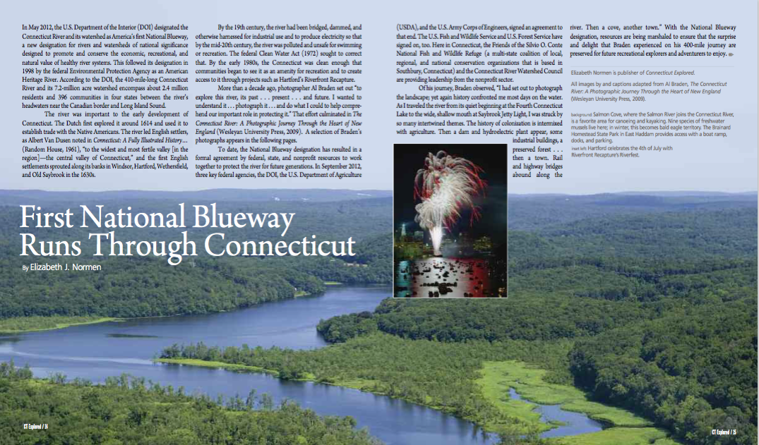
[Top image] p. 14 Salmon Cove, where the Salmon River joins the Connecticut River, is a favorite area for canoeing and kayaking. Nine species of freshwater mussels live here; in winter, this becomes bald eagle territory. The Brainard Homestead State Park provides access with a boat ramp, docks, and parking.
p. 15 inset: Hartford celebrates July 4th with Riverfront Recapture’s Riverfest.
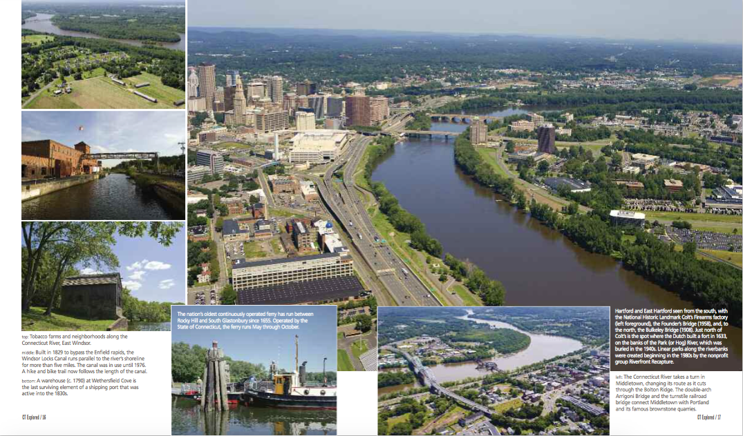
p. 16 (top left) Tobacco farms and neighborhoods along the Connecticut River, East Windsor. (left middle) Built in 1829 to bypass the Enfield rapids, the Windsor Locks Canal runs parallel to the river’s shoreline for more than five miles. The canal was in use until 1976. A hike and bike trail now follows the length of the canal. (left bottom) A warehouse (c. 1790) at Wethersfield Cove is the last surviving element of a shipping port that was active into the 1830s. (bottom right) The nation’s oldest continuously operated ferry has run between Rocky Hill and South Glastonbury since 1655. Operated by the State of Connecticut, the ferry runs May through October.
p. 17 Hartford and East Hartford seen from the south, with the National Historic Landmark Colt’s Firearms factory (left foreground), the Founder’s Bridge (1958), and, to the north, the Bulkeley Bridge (1908). Just north of Colt’s is the spot where the Dutch built a fort in 1633, on the banks of the Park (or Hog) River, which was buried in the 1940s. Linear parks along the riverbanks were created beginning in the 1980s by the nonprofit group Riverfront Recapture. (bottom) The Connecticut River takes a turn in Middletown, changing its route as it cuts through the Bolton Ridge. The double-arch Arrigoni Bridge and the turnstile railroad bridge connect Middletown with Portland and its famous brownstone quarries.
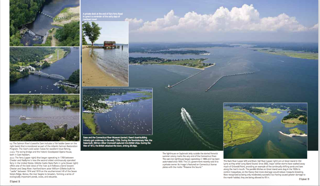
p. 18 ( top left) The Salmon River’s Leesville Dam includes a fish ladder (seen on the right bank) that is monitored as part of the Atlantic Salmon Restoration Program. The river’s cold water makes for excellent trout fishing. (middle left) The swing bridge in East Haddam, and the historic Goodspeed Opera House. (bottom left) The ferry (seen in the upper right of photo) that began operating in 1769 between Chester and Hadlyme is now the second oldest continuously operated ferry in the United States. Gillette Castle State Park in Lyme (lower right) offers one of the best views of the river as it follows a bend toward Chester and Deep River. Hartford-born actor William Gillette built his “castle” between 1914 and 1919 on the southernmost hill of the Seven Sisters Ridge. Below, the river begins to broaden, forming a series of ecologically important ponds, coves, and estuaries. (center top) A private dock at the end of Ely’s Ferry Road in Lyme is a reminder of the early days of riverboat travel. (center bottom) Essex and the Connecticut River Museum (center). Essex’s boat-building industry got underway in the early 1730s. During the Revolutionary War, the Essex-built, 300-ton Oliver Cromwell captured nine British ships. During the War of 1812, the British attacked the town, sinking 28 ships.
p. 19 The lighthouse on Saybrook Jetty outside the storied Fenwick summer colony marks the very end of the Connecticut River. The cast-iron lighthouse began operating in 1886 and has been automated since 1959. The U.S. government recently sold it to a private owner. Its image is featured on Connecticut license plates with the motto “Preserve The Sound.” (bottom right) The Black River (upper left) and Black Hall River (upper right) join at Great Island in Old Lyme as they enter Long Island Sound. Since 2002, major winter storms have washed away much of Griswold Point, providing an example of the continually shifting sands and bars along the river’s mouth. The parallel ditches on Great Island were dug in the 1930s to control mosquitoes, on the theory that more drainage reduced mosquito breeding. Now recognized as only moderately successful but having caused greater damage to the marsh habitat, they are being allowed to fill in.
Explore!
Spring 2021: Our Environmental History
Read more stories about Connecticut’s historic landscape and environment on our TOPICS page.